
This weekend Brook, Noah, Kirsten and I decided to save some money and try a hitchhiking trip. From talking to a few people I gathered that hitchhiking in Iceland is both safe and easy. Apparently tourists rarely pick up strangers while locals are more willing. We packed for an overnight trip and set out from the city bus terminal around 11:00. We took a local route to the edge of town, where we walked towards highway 1 (the ring road). There was little chance that a group of four could get picked up, so we split into two groups. We split up and Brook and I laid down bags and stuck out our thumbs.
It was about 5 minutes before an older Mercedes pulled to the side of the road. We jumped in and asked where they were going. They were heading just out of town to an old coffee house, so we decided to get as far as we could. The driver was a native Icelander and his brother from Berlin was riding shotgun. We swapped traveling stories and talked about old Mercedes. The car we were in was a 1992 Mercedes 300E. He said he preferred the 6 cylinder to the 4 cylinder, but had never had a diesel. As we pulled into the coffee shop / gas station the driver handed us two CD’s from his daughters band, titled Rocketgirl. Realizing that we were both hungry and seeing that it was nearly 1:00, we decided to eat at the Cafe. Other than cold sandwiches the only option was an Icelandic meat soup. Unfortunately it was nearly 1500 Krona per bowl (~ 13 USD) so I asked the waitress to use their microwave. They happily obliged and allowed us to heat up some crepes and pasta from last nights dinner.
When we finished eating we set out to find another ride. We weighed our options for the best location to get picked up. We reasoned that the drivers need a few conditions to be met for a successful stop:
• Time to see us, make a decision and react
• Ample room to pull safely off the road
• Motivation to pick us up
The best location was the interior hazard lane of the highway. We put on our best smiles and waited. A few cars passed us, many of them waving or shrugging. After about 15 minutes our work paid off. A white Renault van pulled off to the side. We scoped up our backpacks and ran towards the van. The driver was an Icelander who spoke limited English, but was friendly. He owned a painting business and was just driving to the next town Hverageroi, but it was not an easy spot to get a ride so he would bring us to the next town of Selfoss. We thanked him profusely and got off near the edge of Selfoss, ready for the next car. We set up about 30 meters after the round about leaving town. Figuring that the cars would have to slow down for the roundabout and may have time to pick us up.
It was nearly 10 minutes of waiting before a black van pulled up beside us. The driver was an older German lady who worked as a massage therapist in Iceland. Her front seat passenger was a girl from New York who was couch surfing though Iceland on a birthday trip and the lady in the backseat with us was a jewelry designer who was from Canada, but had lived in Reykjavik for the past 20 years. They were all very friendly, but they were only going about 15km before they turned off of highway 1. I mentioned the two copies of the CD that had been given to us by our first driver and offered them a copy. Before long we reached road 30, which branched north off of the highway. We said our goodbyes and stood at an intersection in the middle of nowhere.
As we got further away from Reykjavik, the traffic decreased. Luckily after only a few minutes of waiting, a new looking Toyota land cruiser stopped for us. The driver was an older Icelandic lady who lived in the next town, Rangringytra. When we told her of our plans for the hot springs, she told us the name of her favorite one. Unfortunately, if you don’t get people to write down names, it is nearly impossible to remember, pronounce or spell any of these locations in Iceland. When we arrived in Rangringytra, we once again set up after the main roundabout. The weather had begun changing from a nice sunny day to windy and cloudy. This was our longest wait, taking maybe 45 minutes to catch a ride. As we were loosing hope, a blue Nissan pulled up. The driver said he was only going to the next town (seeing a pattern yet?), but it may be easier to catch a ride from there. He was a middle-aged man who used to do professional horseback riding, but had an accident and now cannot compete.
The next town stopped in was Hvolsvllur, which was not much of a town at all and was the last town before our destination. We had another long wait for a ride. 30 minutes passed before a car stopped. This small white Chevy was a rental car driven by two exchange students. One was from Germany and studying economics, while the other was from Finland and was studying teaching. They said that they could give us a ride to the road we need to hike down, but they planned on stopping at a waterfall beforehand. The waterfall Seljalandsfoss, is a famous tourist sight. This is most likely because you can drive to it. The one unique thing about this falls is that when the sea level was higher, it carved out the area behind the falls, leaving an indentation where you can walk behind the waterfall. About 200m down the path from Seljalandsfoss is a less visited falls named Gljufrabui. This falls is hidden behind a canyon. If you brave through the icy spray of water, you get to an opening in the canyon where the falls are visible. Our waterproof layers were completely drenched, but it was an amazing site. When we finished with the falls, we de-mudded ourselves got back in the rental car.
They dropped us off at an unlabeled road a few kilometers after the waterfalls. Noah and Kirsten had the only map, so we were relying on a picture of the map taken by a blurry cell phone camera. Brooke and I begun our hike down the road which ran next to a farm and into a valley shaded by the ice covered Eyjafjallajkull Volcano. The time was 6:00 and night was rapidly approaching. We still had no contact with Noah and Kirsten, so we decided to find the hot springs.
We hiked for a half an hour down the dirt road before it came to an end at a farm. Past this was a riverbed that continued up the canyon. Another 20 minutes of hiking brought us to our destination, Seljavallalaug hot springs. Seljavallalaug is the oldest pool in Iceland and was built to teach Icelandic fisherman how to swim after many of them were drowning out at sea. The pool is situated in an amazingly beautiful area. It is nestled in a small valley that looks out into the sea and has the ice covered caps of Eyjafjallajokull towering above it. The downside of the pool is that it is not very hot and has not been maintained for nearly 40 years. Waiting at the pool were Noah and Kirsten. They had only had two car trips, instead of our 6, and had arrived two hours before us. We made camp next to the springs and soaked. That night we met a girl from Santa Barbara and two Danish travelers who shared some Japanese whiskey with us. Our dinner was partially cooked tortellini and baked bean hotdogs.
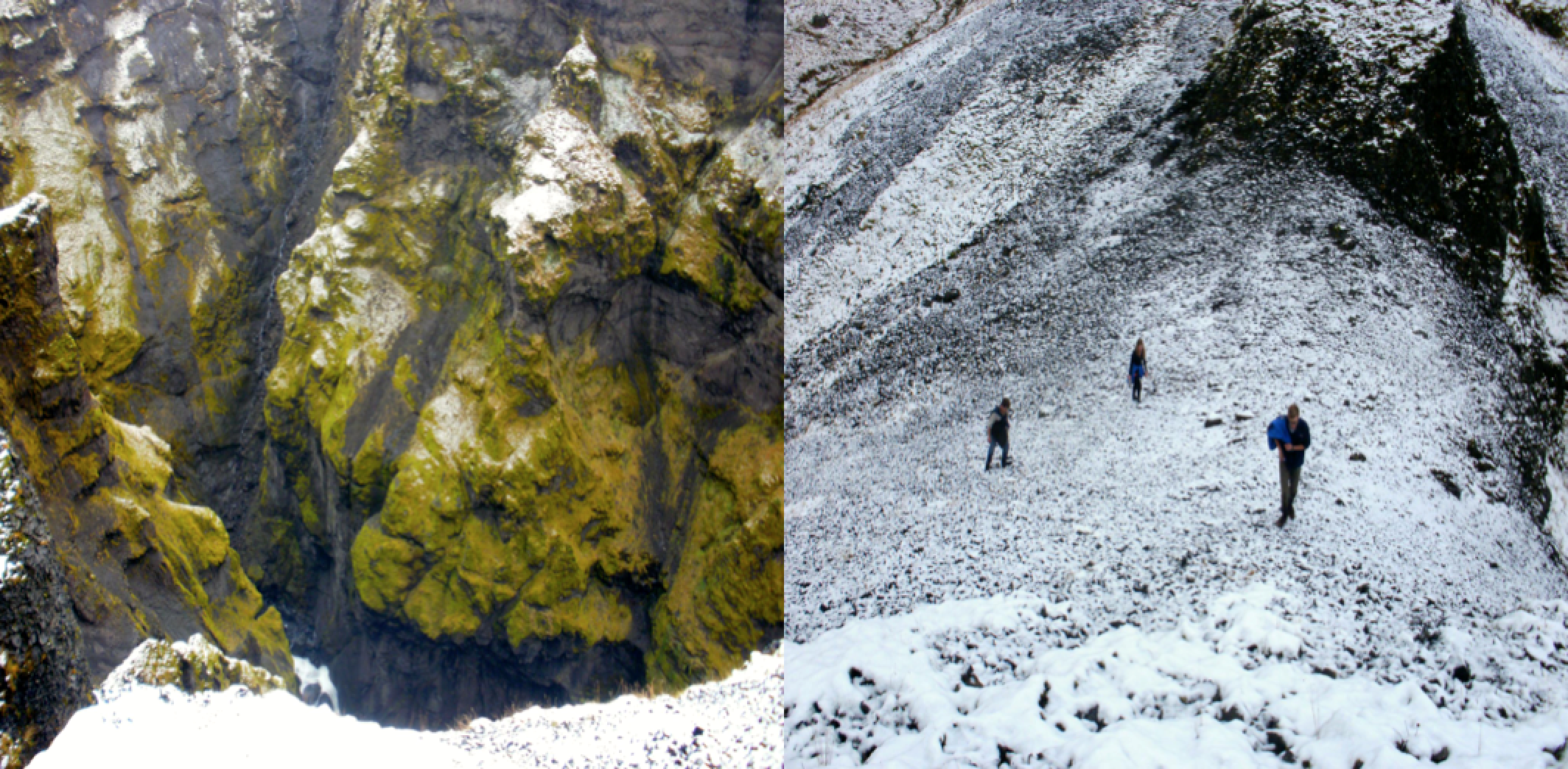
The next morning I woke up to find my backpack, sleeping bag and nearly all of my clothes soaked. My backpack had pushed against the rainfly, which created an opening for the night rain to enter. We laid our belongings out to dry and set out for a morning hike. Looking at the map, we decided to hike up the left fork of the river in hopes of reaching a tongue of an outlet glacier. The path soon disappeared and we couldn’t continue any further up the canyon. As a group we decided to attempt to fjord the river to find another route. The flattest spot looked only up to our ankles, but was wide. I removed my already wet shoes and socks and tested the water. The water was of course freezing being that it had melted from a glacier less then a kilometer away. After we all froze our feet, we decided that it wasn’t worth crossing. Once again we retraced our steps and made it back to the hot springs. From there we hiked straight up the side of the hill next to the pool. We climbed about 700 meters and got an amazing view of the icecap. There was a light snow from the night before that was melting, which prompted a summit snowball fight. Realizing that we only had a few more hours of daylight left, we headed for the pools.
We made a quick lunch out of pesto and potatoes and warmed our feet in the springs before heading to the road. About halfway up the road, a purple Subaru legacy passed us and I jokingly stuck out a thumb. They pulled o↵ and we asked where they were going. They were heading East on the 1, while we were going West. Being tired and wet from our hike we asked for a ride to the ring road. Their car was packed full of gear and there were 7 of us total, so we opened up the rear hatch and sat on the bumper and held on for dear life. At highway 1 we split up again into groups of two.
This time Brook and I volunteered to start walking. We made it about a kilometer down the road before a large maroon red ford van stopped for us. The driver was an old Icelandic man who was driving to Reykjavik. We happily got in and made conversation. He spoke quietly and his English was rusty. The van was loud and the automatic transmission was on its way out, so understanding him was even more of a challenge. He regularly told us about historical eruptions and features of the landscape. He also knew two of our geology teachers and where one of them was born. We pieced together that he was some type of farmer and that he had done a Caribbean cruise and was planning another.
When we entered Reykjavik he dropped us off in front of our residence and drove away. The trip was a wonderful experience. The hitchhiking not only saved us the cost of renting a car, but also allowed 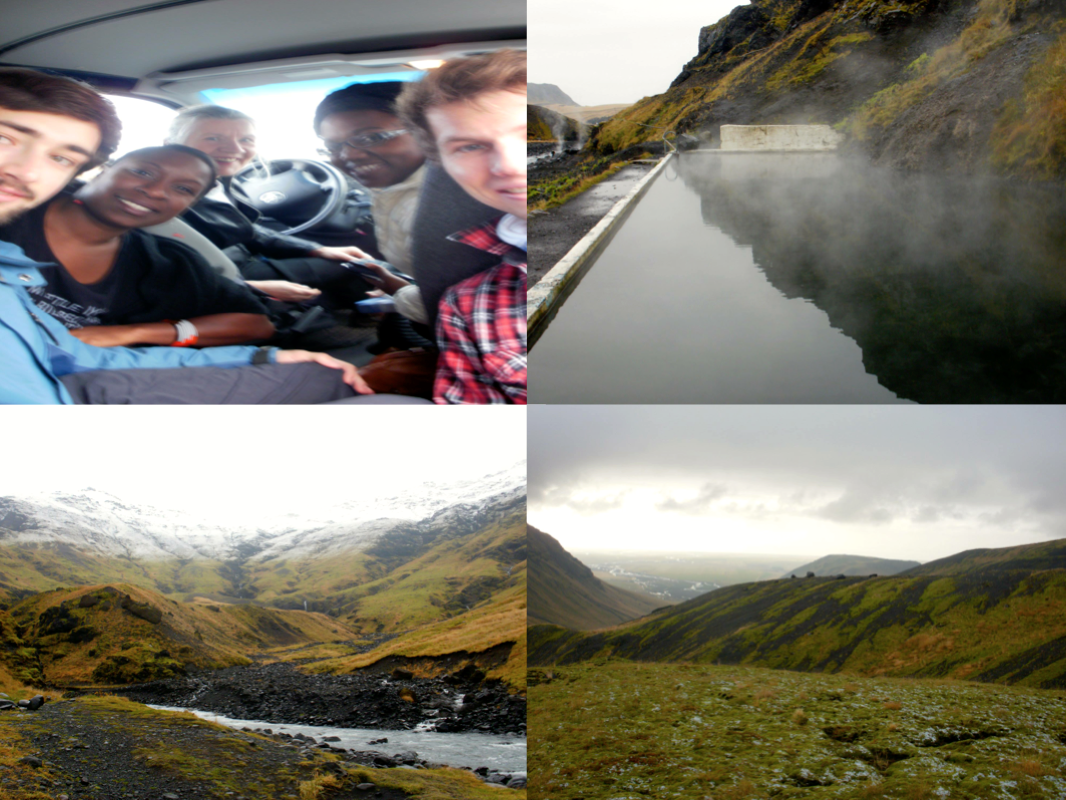
 us to meet many new people.


